Roanoke-Hatteras Tribal History “The People of the Coast" are a part of a group of Indians known as the Carolina Algonkians, the name “Algonkians” taken from their language group. They were the southern most speakers of the eastern Algonkian language, distributed from the Neuse River in North Carolina to the maritime provinces of Canada . It was Algonkian-speaking people who took the brunt of English exploration and colonization beginning at Roanoke Island in 1584, continuing at Jamestown in 1607, Plymouth in 1620, and all succeeding colonies along the Middle Atlantic and northeastern coast of North America. It is believed that the colonists who settled Roanoke Island had contact with Algonkian Indians known as the Secotan Tribe(s) whose domain extended from the Albemarle Sound to lower Pamlico River and from Roanoke Island westward to present-day Bath , North Carolina. The Roanoke Indians and the Croatoan Indians (called Hatteras after 1701), were two nations of the Algonkian speaking people of North Carolina . The original home of the Croatoan included what is now Hatteras Island from the current town of Buxton south, and the eastern part of Ocracoke Island . After 1650, and the closing of the Chacandepeco Inlet, they moved onto that part of Hatteras Island from Avon to Rodanthe. The capital of the Croatoan Indians was that of the same name located underneath what is now the Town of Buxton , N.C. The original territory of the Roanoke Indians was Roanoke Island and the Dare County mainland as well as adjacent parts of Bodie Island on the east. The Roanoke Indians called themselves “ the northern people ” because tradition says they lived at the north end of Roanoke Island. Their capital town was Dasemonquepuc located at modern day Mann's Harbor, North Carolina. The Hatteras Indians called themselves “the people of shallow waters”.
The tribes were ruled by a leader called “ Manamatowick ”. The paramount chief, or Manamatowick, usually controlled between six or eight towns, although some ruled as many as eighteen and could gather seven to eight hundred warriors. At the time of English colonization on Roanoke Island, Wingina, ruled over Dasemonquepuc, Roanoke Island , and possibly the towns of Tramaskecooc, Croatoan, Aquascogoc, Pomeiooc, Cotan, Secotaoc, and Secoton. Each town had its own subchief called “Werowances”.
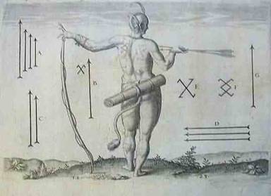
The inhabitants of this country usually have marks on their backs whereby it may be known Written history of the Roanoke and Croatoan Indians began in July 1584, when two English ships under the command of Philip Amadas and Arthur Barlowe anchored near an island on the Outer Banks of North Carolina . Barlowe described his first meeting with the Indians of the new land and soon afterward traveled to Roanoke Island where he was entertained in a palisade town containing nine longhouses. Barlowe references are as follows: “ My self[e] with seven more went twentie mile into the River that runneth toward the Citie of Skicoak, which River they cal Occam, and the evening following wee came to an Island which ehry call Roanoak, distant from the harbour[inlet] by which we entred seven leagues. At the North end thereof was a village of nine house, built of Cedar, and fortified round about with sharp trees to keep our their enemies, and the entrance into it made like a turne pike very artificially. When we came towards it standing neere unto the waters dide, the wife of Granganimo, the kings brother, came running out to meete us very cheerfully and friendly. Her husband was not then in the village….” John White spoke of Roanoke as the “ the island directly over against Dasamonepeuk ”. It is believed that Wingina lived at either Roanoke (Wingandacoa) or Dasamonquepuc. According to Lane, “ the King…sow[ed] his ground, not onely in the Iland, but also at Dasamonquepeio and that Pemisapan [Wingina] went of purpose to Dasamonwuepeio.. To see his grounds there broken up and sowed for a second crop .” In 1585, Ralph Lane established his colony on the north end of Roanoke Island and built the fort known today as Fort Raleigh . Shortly after the colonist built their settle- ment on the Island , the native town and the entire island seem to have been abandoned by the Indian inhabitants. This was done after the death of Granganimo and his father Ensenore; who were Roanoke Indians and friendly to the English. Wingina decided to oppose the English. Wingina lead the most powerful nation south of the Powhatan. Soon after, conflict broke out between the English colonist and the Roanoke Indians. Ralph Lane , the military commander of the colony defeated the Roanoke Indians. He burned the town of Dasamonquepuc and killed their ruler, Wingina, thus creating a situation of dispersal of the group. The Roanoke Indians fled to the remote mainland town of Tramakecooc at the base of the Alligator River . Wanchese gathered together the remnants of his tribe. He married the sister of Wingina: Appomsiscut. They had a daughter named Ascopo. Historical records do not indicate when Wanchese died. Tribal tradition says that he was buried on Roanoke Island at the south end near the Town of Wanchese. There was no Indian town on Roanoke Island in 1587, when John White, Governor, established his colony. Indians only visited the island from the mainland to hunt and fish. Governor White, after the killing of a colonist, ordered an attack on Wanchese and the Roanoke Indians at Dasamonquepuc. However, many Croatoans were killed also. Manteo was baptized and proclaimed “Lord” of the Croatoan and Roanoke Indians. Given the disarray of the latter, this created one government for both groups. After the 1650's and the movement of English colonists southward from Virginia into the area, there was an obvious slow collapse of the Indian chiefdom, with the population simply fading into the local background. Tradition states that the Roanoke Indians joined the Tuscarora, Mattamuskeet, Pamlico, Coree, and Bear River Indians in the Tuscarora War from 1711-1713. The Croatoan Indians now called Hatteras sided with the English. With the end of the Tuscarora war, the remnants of the Algonkian tribes continued to fight until 1718 when a peace treaty was signed. As a result of the treaty, a reservation of 10,424 acres was set-up at Lake Mattamuskeet . Some Roanoke Indians may have lived there initially, but most continued to live on the Dare County mainland. The Croatoan (Hatteras) remained intact on Hatteras Island as late as 1759, when Royal Governor Dobbs established a reservation of 200 acres for William Elks and the rest of the Hatteras Indians. The reservation was established at a time when colonist were beginning to populate Hatteras Island. Because of steady encroachment of colonist onto the reservation and European introduced diseases, the Hatteras sold their reservation lands. Even though the original land grant to the Hatteras Indians called for 200 acres, the recorded land sales between the Indians and the colonist indicates that the “Indian Lands” comprised more than 200 acres. There are several deeds on record that reflect the following: 1. A deed from William Elks to William Clarke for the sale of a part of “Old Indian Town ” it states, “and no Indian shall interfere with your rights to this land in any way.” 2. Another deed dated 1777 reflects the sale of 100 acres “part of Old Indian Town” to Isaac Farrow. 3. A deed dated 1788 from Mary and Elizabeth Elks, both Indians, for the sale of two hundred acres “ Old Indian Town ” to Nathan Midyett. 4. Lastly, a deed from Elizabeth Elks, Native Indian, dated 1802 in trust to Nathan Pinkham for land known as “Indian lands……” and Nathan Pinkham shall have this land to use, occupy, and enjoy all the profits of the said lands and timber without any molestation or hindrance of any white person whatsoever …” “during his natural life provided my son live to the age of twenty-one years, then and in that case the land shall be at my son's disposal and for his only…” Exactly twenty-one years later the deed is recorded (1823). It mentions that Elizabeth Elks and Nathan Pinkham are dead; however, it does not state whether any land was turned over to her son or anyone else.
Henry Gibbs Deed
Elks-Pinkham Deed In May, 1761, The Rev. Alexander Stewart, a missionary of the Society for the Propagation of the Gospel, wrote of his visit to Hyde County , including this mention: “I likewise with pleasure inform the society, that the few remains of the Altmuskeet [Mattamuskeet], Hatteras, and Roanoke Indians (whom I likewise mentioned in a former letter) appeared mostly at the Chapel and seemed fond of hearing the Word of the true God and of being admitted into the Church of our Lord Jesus Christ. 2 men and 3 women and 2 children were baptized by me. I could have wished the adults were better instructed, but their sureties and a northern Indian among them, who had been bred as a Christian promised to take that care”. Two years later (1763), the same clergy made another voyage to Hyde County and reported: “The remains of the Altamuskeet, Roanoke , and Hatteras Indians, live mostly along the coast, mixed with the white inhabitants, many of these attend at the places of Public worship, while I was there and behaved with decency, seemed desirous of instruction and offered themselves and their children to me for baptism. And after examining some of the adults I accordingly baptized, 6 adult Indians, 6 boys, 4 girls, 5 infants and for their further instruction (at the expense of a society called Dr. Bray's associates; who have done me the honor of making me Superintendent of their schools in this Province) have fixed a school mistress among them, to teach 4 Indian boys and 2 Negro boys and 4 Indian girls to read and to work and have supplied them books for that purpose and hope that God will open the eyes of the whites everywhere that they may no longer keep the ignorant in distress but assist the charitable design of this Pious Society and do their best endeavours to increase the Kingdom of our Lord Jesus Christ.” The Indian settlements on the Dare County mainland at the time of Rev. Stewart were a mixture of Roanoke and Hatteras Indians. Maps of the area have the name “Croatan or Croatan Land ” written in the vicinity of Mann's Harbor and Beechland. This possibly indicates the Indians continued to live there and own the land. In 1777, Indians sold the land at Buck's Ridge in the vicinity of Mann's Harbor and Beechland. In the public records of Currituck, Hyde, Tyrrell, and later Dare County (which was formed in 1870 from Currituck, Hyde, and Tyrrell), the Hatteras and Roanoke Indians were not referred to as “Indian” after the 1800's. They were generally grouped with “Free Blacks” and designated as “Free Persons of Color” or “Mulatto”. In the period between 1835 and 1865, it was common practice to place children of “free persons of color” in indentured apprenticeships, removing them from their families and their roots until they reached the age of 21. Whatever remnants of the Roanoke and Hatteras Indians' culture passed into the 19 th century was largely destroyed by the apprenticeship practices. The Collins family was represented by apprentice bonds on ten different individuals. One member of the Pugh family was apprenticed. The Bowser family was represented by apprentice bonds on twenty-one different individuals. The Baum family was represented by one apprentice bond as well as the Elks and Scarborough families. Also one member of the Berry family was apprenticed. All of the contemporary descendants of the Roanoke-Hatteras Indians are descended from individuals listed on the apprentice bonds.
In spite of all this, Roanoke and Hatteras Indians have remained in the area of the Roanoke and Hatteras Islands and the Dare County Mainland until present day. They became the subject of field studies in 1916 when Frank G. Speck, noted anthropologist of the University of Pennsylvania and the Smithsonian Institute wrote about them. He erroneously called them the remnants of the Machapunga Tribe. Speck believed that the Mattamuskeet or Machapunga, the Roanoke , and the Hatteras Indians were the same people. They did speak the same dialect, the Algonkian language, however; they were different tribal groups. He further noted the Indian ancestry of the Berry , Daniels, Pugh, and Wescott families. Speck wrote in 1924 that there were over 100 Indian descendants living on the Islands. Because the government did not recognize the Indian descendants as “Indian” or their aboriginal title to the land, many of them purchased land on Hatteras and Roanoke Islands . Smith Pugh purchased some of his tribe's former lands on Hatteras Island in 1847. Members of the Scarborough Family also purchased land on Hatteras Island . The descendants of the Roanoke-Hatteras Indians owned land on Hatteras Island until the late 1960's or early 1970's. Between the 1890'sand 1900's, Lemuel Collins , Thomas Scarborough, and Joseph Hall Berry , purchased land in the Butt Swamp area of Roanoke Island. The tracts of land that they purchased would become the center of the distinct Indian community on Roanoke Island. Joseph Hall Berry was the son of Zion Hall Berry. Zion Hall Berry, a
powerful preacher, is referenced in several church histories as being
full-blooded Indian. Joseph Hall Berry married Angenora Pugh, the daughter
of Smith and Annie Pugh, a Hatteras Indian from Hatteras Island. By the
1890's, the Pugh Family sold their land on Hatteras Island and relocated to
the Berry settlement located in today’s “Suple's Hill Community”. Historical Family Boat the “Ella View”
You can see one of Creef's original shad boats, the Ella View, in a boat shed next to the Creef Boat Museum in Manteo, NC . The shad boat is on loan from the Mariners' Museum in Newport News , Va. The George Washington Creef, a working boathouse, offers a look at local and regional maritime heritage through displayed watercraft, exhibits, restoration projects, and traditional skills workshops.
The Roanoke and Hatteras Indians were great fishermen and hunters. They were skilled conservationist and agriculturalist. Many of the skills were shared with the early European colonists. The descendants of the Roanoke-Hatteras Indians continued to practice many of the hunting and fishing, and farming skills of their ancestors as a means of providing income and food for their families. Even though there exists no written history of our traditional material culture and practices, oral history is passed from generation to generation. The descendants of the Roanoke and Hatteras Indians were very instrumental in the organizing and the building of Haven Creek Baptist Church in Manteo , N.C. Prior to the organization of Haven Creek Church , the people were Episcopalians and Methodist. The Roanoke-Hatteras Indians continue to live on Roanoke Island . According to the 2000 Census, there are 83 Indians living in Dare County . Some families have moved to Elizabeth City , NC, Maryland , New York , and others to the Virginia Tidewater area. Yearly family reunions bring the families back to the Suple's Hill community of Roanoke Island and Salvo Community of Hatteras Island. These yearly reunions strengthen and renew family ties. They also allow us to preserve and pass on our oral history and traditions. Since August, 2004, our annual powwow is held on Roanoke Island . In 2003, the descendants formally re-organized and established the council called the Algonquian Indians of North Carolina, Inc. based in Manteo , NC . The Algonquian Indians is a 501C 3 approved non-profit organization since May 2003. The Roanoke-Hatteras Indian Tribe continues to conduct historical and genealogical research with the intent of filing a petition with the North Carolina Commission on Indian Affairs for official recognition as an Indian Tribe. Roanoke-Hatteras Culture Living the Past The Roanoke-Hatteras elders provide a view of the past and a vision for the future. Their memories connect Roanoke-Hatteras of today with past generations. Their knowledge and wisdom offer valuable perspectives for future generations. Interviewers with the Roanoke-Hatteras Elders Oral History Project have been collecting oral histories from the elders on tape. We hope to develop and online exhibit highlighting the contents of the tapes, looking at the elders' memories of food, crafts, herbal cures, annuity cloth, and land claims. We thank the following elders who have worked with the project and have shared their knowledge and memories with us all.
ACKNOWLEDGEMENT AND COPYRIGHT INFORMATION
The previous information indicated in the Roanoke –Hatteras Indians' Tribal History come from many sources. The Tribe is documenting its tribal history in order to prepare a petition for state recognition as an “Indian Tribe”. We would like to thank the editors of the Hyde County web page and Dr. David Phelps. The tribal editor apologizes for failure of proper attribution. However, the material contained in the Tribal History is being copyrighted. Please do not cite or use without the Roanoke-Hatteras Indian Tribal Council's permission. Research is costly and time consuming. If you have information that will help our Tribe, or would like to volunteer your time and service, please do not hesitate to contact us. (All information used is from independent authors, we do not have the resources to check the contents of these files for copyright infringements. We assume that the authors have given full credit where required. However, sometimes an infringement can still occur. If this is the case, and you own the copyright and wish to have the file removed, please inform us, and we will remove the information.) We can be reached at 757-477-3589. |
© 2023 Algonquian Indians of North Carolina, Inc., a 501c3 organization. All rights reserved.